
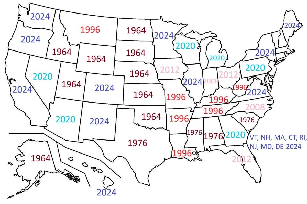
@scarlett_sData on the most recent year every U.S. state voted for a Democrat for President, including DE
Vedi post originale@scarlett_sData on the most recent year every U.S. state voted for a Democrat for President, including DE
Vedi post originaleFoto di @scarlett_s· Nov 5, 2026· Politics
This image is a political map of the United States with each state labeled by a year in various colors. The years shown are mostly 1964 in red across the middle of the country, 2024 in blue on the coasts and northern states, 2020 in cyan in scattered western and northeastern states, and 1996 and 1976 in pink or red in the South and parts of the Midwest. A small cluster of northeastern states is labeled in the bottom right corner with the text “VT, NH, MA, CT, RI, NJ, MD, DE-2024”. The map has a clean, minimalist infographic style with bold black state outlines on a white background. The most notable detail is the heavy concentration of the year 1964 stamped across the nation’s heartland.
 Pope Leo XIV meets Bob Dylan
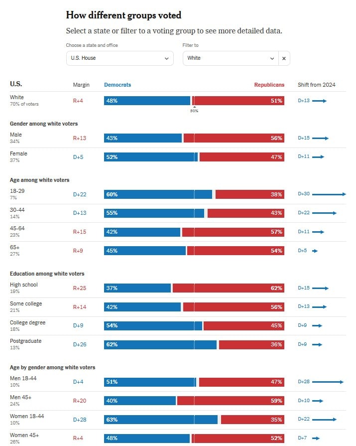 White voter shifts toward Democrats
 2US voters reject data center expansion
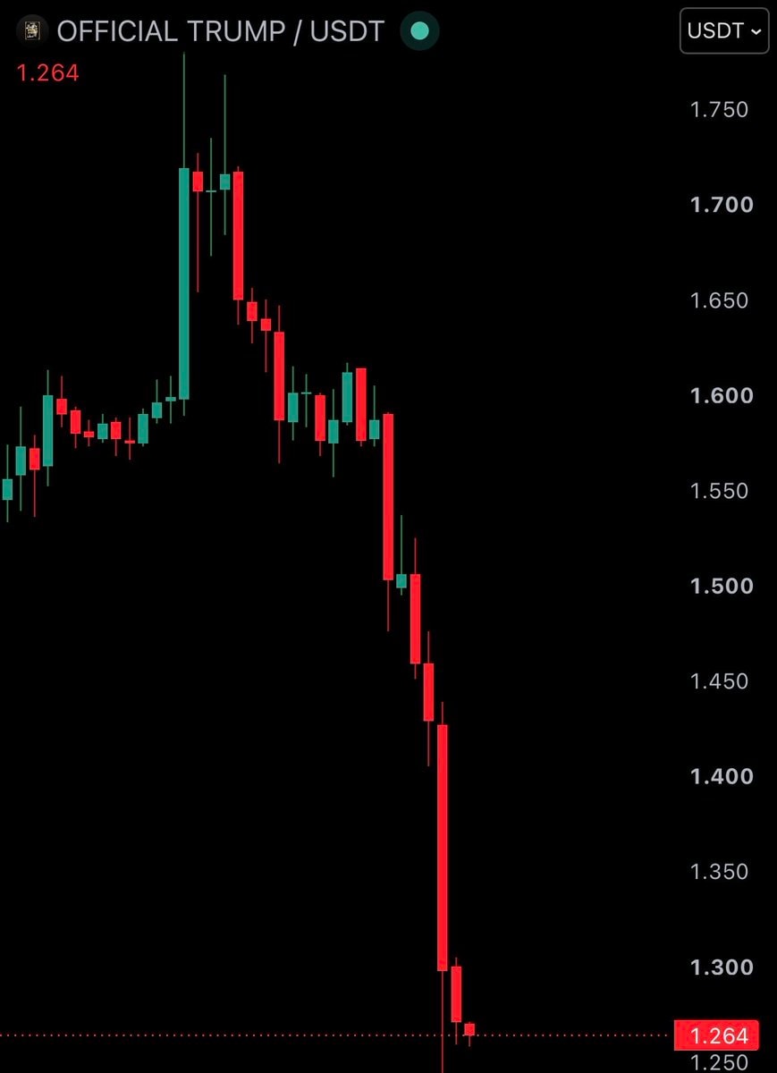 OFFICIAL TRUMP / USDT crash
 2US Muslim mayor and senator historic moment
 2NYT 2026 election demographics shift toward Democrats
 2Asmongold X profile update
 Dr. Abdul El-Sayed historic win
 2David Morales elected mayor of Providence
 2NYC Mayor Zohran Mamdani on Michigan Senator
 Netanyahu Israel election result
 2Democrats U.S. Senate control
 Argentina official map
 Matt Binder on Elon Musk and midterms
 JD Vance presidential question
 David Morales elected mayor
 Trump stock market record high
 Jon Ossoff Tony Goldwyn photo
@scarlett_sData on the most recent year every U.S. state voted for a Democrat for President, including DE
Vedi post originaleFoto di @scarlett_s· Nov 5, 2026· Politics
This image is a political map of the United States with each state labeled by a year in various colors. The years shown are mostly 1964 in red across the middle of the country, 2024 in blue on the coasts and northern states, 2020 in cyan in scattered western and northeastern states, and 1996 and 1976 in pink or red in the South and parts of the Midwest. A small cluster of northeastern states is labeled in the bottom right corner with the text “VT, NH, MA, CT, RI, NJ, MD, DE-2024”. The map has a clean, minimalist infographic style with bold black state outlines on a white background. The most notable detail is the heavy concentration of the year 1964 stamped across the nation’s heartland.
Ancora nessun commento. Sii il primo!
Pope Leo XIV meets Bob DylanWhite voter shifts toward Democrats2US voters reject data center expansionOFFICIAL TRUMP / USDT crash2US Muslim mayor and senator historic moment2NYT 2026 election demographics shift toward Democrats2Asmongold X profile updateDr. Abdul El-Sayed historic win2David Morales elected mayor of Providence2NYC Mayor Zohran Mamdani on Michigan SenatorNetanyahu Israel election result2Democrats U.S. Senate controlArgentina official mapMatt Binder on Elon Musk and midtermsJD Vance presidential questionDavid Morales elected mayorTrump stock market record highJon Ossoff Tony Goldwyn photo
Ancora nessun commento. Sii il primo!